Chongwe geodata
Chongwe (Lusaka) is a populated place; located in Zambia in Africa/Lusaka (GMT+2) time zone. With population of 6,057 people, there are 53 cities with bigger population in this country. Compared to other cities in Zambia, 77.3% of cities are located further ↑North; 59.1% of cities are located further ←West and 63.6% of cities have higher elevation than Chongwe. Note1


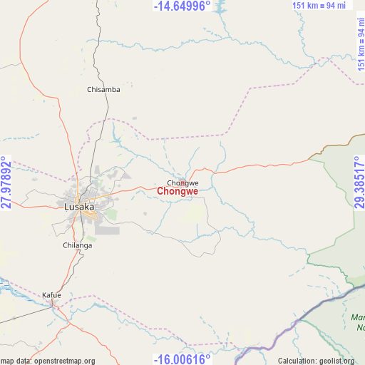
Chongwe GPS coordinates[2]
15° 19' 44.976" South, 28° 40' 55.344" East
| Map corner | latitude | longitude |
|---|---|---|
| Upper-left | -14.64996°, | 27.97892° |
| Center: | -15.32916°, | 28.68204° |
| Lower-right: | -16.00616°, | 29.38517° |
| Map W x H: | 150.8×150.8 km | = 93.7×93.7mi |
| max Lat: | -8.46887° ⇑77.3% North |
| Chongwe: | -15.32916° |
| min Lat: | ⇓22.7% South -17.84194° |
| min Long | Chongwe | max Long |
| 22.67926° | 28.68204° | 33.1782° |
| W 59.1%⇐ | ⇒40.9% E |
Elevation
Elevation of Chongwe is 1102 m = 3615 ft, and this is 41.4 m = 136 ft below average elevation for this country.
| Max E: |
1622 m = 5322 ft | 63.6% |
| Avg. | 1143.4 m = 3751 ft | |
| Chongwe | 1102 m = 3615 ft | |
Min E: |
328 m = 1076 ft | 36.4% |
See also: Zambia elevation on elevation.city.
Geographical zone
Chongwe is located in South Torrid zone (between Equator and Tropic of Capricorn). Distance of this Southern Tropic circle is 901.5 km =560.2 mi to South.| Distance of | km | miles | from Chongwe |
|---|---|---|---|
| Equator | 1704.4 | 1059.1 | to North |
| Tropic Capricorn | 901.5 | 560.2 | to South |
| Antarctic Circle | 5696.7 | 3539.8 | to South |
| South Pole | 8302.6 | 5159 | to South |


Nearby cities:
15 places around Chongwe: (largest is in red/bold)
• Chibombo
99.5 km =61.8 mi,  318°
318°
• Choma
244.6 km =152 mi,  227°
227°
• Gwembe
173.5 km =107.8 mi,  221°
221°
• Kabwe
101.3 km =62.9 mi,  345°
345°
• Kafue
72.6 km =45.1 mi, 227°
• Kapiri Mposhi
151 km =93.8 mi,  359°
359°
• Luangwa
188.6 km =117.2 mi,  99°
99°
• Lusaka
43.2 km =26.8 mi,  258°
258°
• Mazabuka
115.9 km =72 mi,  239°
239°
• Mkushi
204.9 km =127.3 mi,  21°
21°
• Monze
166.4 km =103.4 mi, 230°
• Mpongwe
210.2 km =130.6 mi,  344°
344°
• Mumbwa
178.1 km =110.7 mi,  282°
282°
• Nakambala
111.7 km =69.4 mi, 239°
• Siavonga
134.5 km =83.6 mi,  178°
178°
Sources, notices
• [Note1] Compared only with cities in Zambia existing in our database
• [Src1] Map data: © OpenStreetMap contributors (CC-BY-SA)
• [Src2] Other city data from geonames.org with taken over terms of usage.
• [Src3] Geographical zone / Annual Mean Temperature by Robert A. Rohde @ Wikipedia
