Mkushi geodata
Mkushi (Central) is a populated place; located in Zambia in Africa/Lusaka (GMT+2) time zone. With population of 12,306 people, there are 34 cities with bigger population in this country. Compared to other cities in Zambia, 54.5% of cities are located further ↑North; 68.2% of cities are located further ←West and 65.2% of cities have lower elevation than Mkushi. Note1


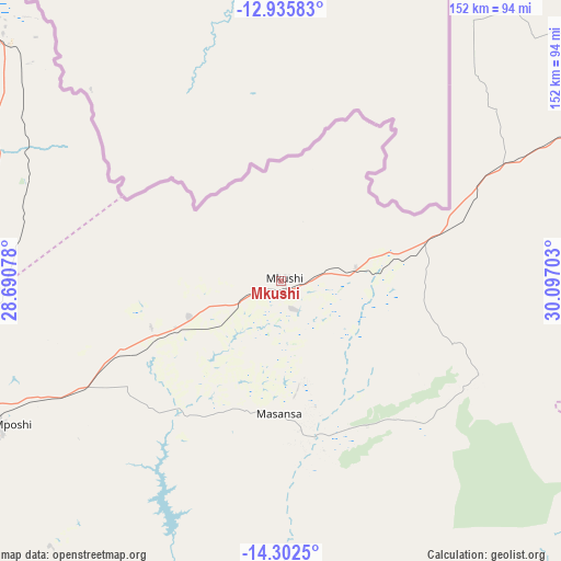
Mkushi GPS coordinates[2]
13° 37' 12.54" South, 29° 23' 38.04" East
| Map corner | latitude | longitude |
|---|---|---|
| Upper-left | -12.93583°, | 28.69078° |
| Center: | -13.62015°, | 29.3939° |
| Lower-right: | -14.3025°, | 30.09703° |
| Map W x H: | 152×152 km | = 94.4×94.4mi |
| max Lat: | -8.46887° ⇑54.5% North |
| Mkushi: | -13.62015° |
| min Lat: | ⇓45.5% South -17.84194° |
| min Long | Mkushi | max Long |
| 22.67926° | 29.3939° | 33.1782° |
| W 68.2%⇐ | ⇒31.8% E |
Elevation
Elevation of Mkushi is 1257 m = 4124 ft, and this is 113.6 m = 373 ft above average elevation for this country.
| Max E: |
1622 m = 5322 ft | 34.8% |
| Mkushi | 1257 m 4124 ft | |
| Avg. | 1143.4 m = 3751 ft | |
Min E: |
328 m = 1076 ft | 65.2% |
See also: Zambia elevation on elevation.city.
Geographical zone
Mkushi is located in South Torrid zone (between Equator and Tropic of Capricorn). Distance of this Southern Tropic circle is 1091.5 km =678.2 mi to South.| Distance of | km | miles | from Mkushi |
|---|---|---|---|
| Equator | 1514.4 | 941 | to North |
| Tropic Capricorn | 1091.5 | 678.2 | to South |
| Antarctic Circle | 5886.8 | 3657.9 | to South |
| South Pole | 8492.6 | 5277.1 | to South |


Nearby cities:
15 places around Mkushi: (largest is in red/bold)
• Chambishi
182 km =113.1 mi,  307°
307°
• Chibombo
183.4 km =114 mi,  231°
231°
• Chingola
203.6 km =126.5 mi, 306°
• Chongwe
204.9 km =127.3 mi,  201°
201°
• Kabwe
137.5 km =85.4 mi, 228°
• Kalulushi
165.1 km =102.6 mi,  301°
301°
• Kapiri Mposhi
87.4 km =54.3 mi,  243°
243°
• Kataba
197.7 km =122.8 mi,  12°
12°
• Kitwe
156.8 km =97.4 mi, 305°
• Luanshya
118.6 km =73.7 mi, 296°
• Mpongwe
134.5 km =83.6 mi,  275°
275°
• Mufulira
172.5 km =107.2 mi, 313°
• Ndola
110.1 km =68.4 mi, 311°
• Nyimba
185.3 km =115.1 mi,  124°
124°
• Serenje
100.7 km =62.6 mi,  64°
64°
Sources, notices
• [Note1] Compared only with cities in Zambia existing in our database
• [Src1] Map data: © OpenStreetMap contributors (CC-BY-SA)
• [Src2] Other city data from geonames.org with taken over terms of usage.
• [Src3] Geographical zone / Annual Mean Temperature by Robert A. Rohde @ Wikipedia
