Kabwe geodata
Kabwe (Central) is a seat of a first-order administrative division; located in Zambia in Africa/Lusaka (GMT+2) time zone. With population of 188,979 people, there are 3 cities with bigger population in this country. Compared to other cities in Zambia, 65.2% of cities are located further ↑North; 54.5% of cities are located further ←West and 53% of cities have lower elevation than Kabwe. Note1


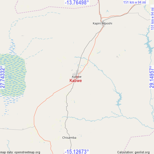
Kabwe GPS coordinates[2]
14° 26' 48.84" South, 28° 26' 47.184" East
| Map corner | latitude | longitude |
|---|---|---|
| Upper-left | -13.76498°, | 27.74332° |
| Center: | -14.4469°, | 28.44644° |
| Lower-right: | -15.12673°, | 29.14957° |
| Map W x H: | 151.4×151.4 km | = 94.1×94.1mi |
| max Lat: | -8.46887° ⇑65.2% North |
| Kabwe: | -14.4469° |
| min Lat: | ⇓34.8% South -17.84194° |
| min Long | Kabwe | max Long |
| 22.67926° | 28.44644° | 33.1782° |
| W 54.5%⇐ | ⇒45.5% E |
Elevation
Elevation of Kabwe is 1191 m = 3907 ft, and this is 47.6 m = 156 ft above average elevation for this country.
| Max E: |
1622 m = 5322 ft | 47% |
| Kabwe | 1191 m 3907 ft | |
| Avg. | 1143.4 m = 3751 ft | |
Min E: |
328 m = 1076 ft | 53% |
See also: Kabwe elevation on elevation.city.
Geographical zone
Kabwe is located in South Torrid zone (between Equator and Tropic of Capricorn). Distance of this Southern Tropic circle is 999.6 km =621.1 mi to South.| Distance of | km | miles | from Kabwe |
|---|---|---|---|
| Equator | 1606.3 | 998.1 | to North |
| Tropic Capricorn | 999.6 | 621.1 | to South |
| Antarctic Circle | 5794.8 | 3600.7 | to South |
| South Pole | 8400.7 | 5220 | to South |


Nearby cities:
15 places around Kabwe: (largest is in red/bold)
• Chambishi
206.2 km =128.1 mi,  348°
348°
• Chibombo
46.7 km =29 mi,  240°
240°
• Chongwe
101.3 km =62.9 mi,  165°
165°
• Kafue
149.7 km =93 mi,  190°
190°
• Kalulushi
182.5 km =113.4 mi, 347°
• Kapiri Mposhi
58.1 km =36.1 mi,  24°
24°
• Kitwe
184.6 km =114.7 mi, 352°
• Luanshya
145.7 km =90.5 mi,  358°
358°
• Lusaka
108.1 km =67.2 mi, 189°
• Mazabuka
173.7 km =107.9 mi,  205°
205°
• Mkushi
137.5 km =85.4 mi,  48°
48°
• Mpongwe
108.9 km =67.7 mi,  343°
343°
• Mumbwa
160.4 km =99.7 mi,  248°
248°
• Nakambala
169.9 km =105.6 mi,  204°
204°
• Ndola
166.7 km =103.6 mi,  7°
7°
Sources, notices
• [Note1] Compared only with cities in Zambia existing in our database
• [Src1] Map data: © OpenStreetMap contributors (CC-BY-SA)
• [Src2] Other city data from geonames.org with taken over terms of usage.
• [Src3] Geographical zone / Annual Mean Temperature by Robert A. Rohde @ Wikipedia
