Luangwa geodata
Luangwa (Lusaka) is a populated place; located in Zambia in Africa/Lusaka (GMT+2) time zone. With population of 3,065 people, there are 63 cities with bigger population in this country. Compared to other cities in Zambia, 80.3% of cities are located further ↑North; 78.8% of cities are located further ←West and 100% of cities have higher elevation than Luangwa. Note1


Luangwa GPS coordinates[2]
15° 37' 0.012" South, 30° 25' 0.012" East
| Map corner | latitude | longitude |
|---|---|---|
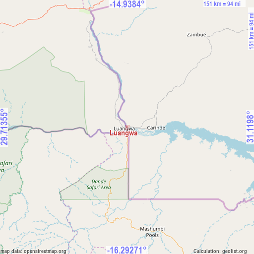
| Upper-left | -14.9384°, | 29.71355° |
| Center: | -15.61667°, | 30.41667° |
| Lower-right: | -16.29271°, | 31.1198° |
| Map W x H: | 150.6×150.6 km | = 93.6×93.6mi |
| max Lat: | -8.46887° ⇑80.3% North |
| Luangwa: | -15.61667° |
| min Lat: | ⇓19.7% South -17.84194° |
| min Long | Luangwa | max Long |
| 22.67926° | 30.41667° | 33.1782° |
| W 78.8%⇐ | ⇒21.2% E |
Elevation
Elevation of Luangwa is 328 m = 1076 ft, and this is 815.4 m = 2675 ft below average elevation for this country.
| Max E: |
1622 m = 5322 ft | 100% |
| Avg. | 1143.4 m = 3751 ft | |
| Luangwa | 328 m = 1076 ft | |
Min E: |
328 m = 1076 ft | 0% |
See also: Zambia elevation on elevation.city.
Geographical zone
Luangwa is located in South Torrid zone (between Equator and Tropic of Capricorn). Distance of this Southern Tropic circle is 869.5 km =540.3 mi to South.| Distance of | km | miles | from Luangwa |
|---|---|---|---|
| Equator | 1736.4 | 1078.9 | to North |
| Tropic Capricorn | 869.5 | 540.3 | to South |
| Antarctic Circle | 5664.8 | 3519.9 | to South |
| South Pole | 8270.7 | 5139.2 | to South |


Nearby cities:
15 places around Luangwa: (largest is in red/bold)
• Chadiza
277.3 km =172.3 mi,  51°
51°
• Chibombo
273.5 km =169.9 mi,  292°
292°
• Chongwe
188.6 km =117.2 mi,  279°
279°
• Gwembe
315.8 km =196.2 mi,  251°
251°
• Kabwe
248.4 km =154.3 mi,  301°
301°
• Kafue
239.9 km =149.1 mi,  265°
265°
• Kapiri Mposhi
262.2 km =162.9 mi,  314°
314°
• Lusaka
229.3 km =142.5 mi, 275°
• Mazabuka
286.8 km =178.2 mi,  264°
264°
• Mkushi
247.8 km =154 mi,  333°
333°
• Nakambala
283.2 km =176 mi, 265°
• Nyimba
125.4 km =77.9 mi,  19°
19°
• Petauke
181.1 km =112.5 mi,  32°
32°
• Serenje
265.8 km =165.2 mi,  355°
355°
• Siavonga
209.3 km =130.1 mi,  240°
240°
Sources, notices
• [Note1] Compared only with cities in Zambia existing in our database
• [Src1] Map data: © OpenStreetMap contributors (CC-BY-SA)
• [Src2] Other city data from geonames.org with taken over terms of usage.
• [Src3] Geographical zone / Annual Mean Temperature by Robert A. Rohde @ Wikipedia
