Mpongwe geodata
Mpongwe (Copperbelt) is a populated place; located in Zambia in Africa/Lusaka (GMT+2) time zone. With population of 8,997 people, there are 42 cities with bigger population in this country. Compared to other cities in Zambia, 50% of cities are located further ↓South; 54.5% of cities are located further →East and 54.5% of cities have lower elevation than Mpongwe. Note1


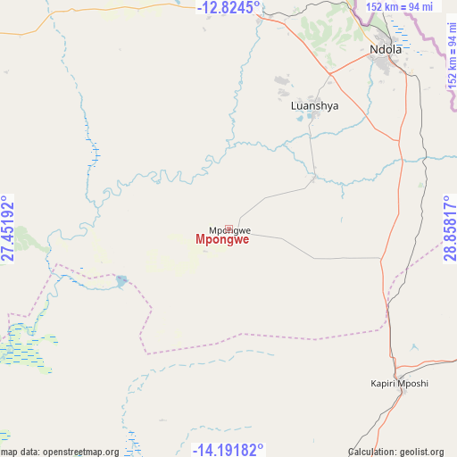
Mpongwe GPS coordinates[2]
13° 30' 32.904" South, 28° 9' 18.144" East
| Map corner | latitude | longitude |
|---|---|---|
| Upper-left | -12.8245°, | 27.45192° |
| Center: | -13.50914°, | 28.15504° |
| Lower-right: | -14.19182°, | 28.85817° |
| Map W x H: | 152×152 km | = 94.4×94.4mi |
| max Lat: | -8.46887° ⇑50% North |
| Mpongwe: | -13.50914° |
| min Lat: | ⇓50% South -17.84194° |
| min Long | Mpongwe | max Long |
| 22.67926° | 28.15504° | 33.1782° |
| W 45.5%⇐ | ⇒54.5% E |
Elevation
Elevation of Mpongwe is 1195 m = 3921 ft, and this is 51.6 m = 169 ft above average elevation for this country.
| Max E: |
1622 m = 5322 ft | 45.5% |
| Mpongwe | 1195 m 3921 ft | |
| Avg. | 1143.4 m = 3751 ft | |
Min E: |
328 m = 1076 ft | 54.5% |
See also: Zambia elevation on elevation.city.
Geographical zone
Mpongwe is located in South Torrid zone (between Equator and Tropic of Capricorn). Distance of this Southern Tropic circle is 1103.8 km =685.9 mi to South.| Distance of | km | miles | from Mpongwe |
|---|---|---|---|
| Equator | 1502.1 | 933.4 | to North |
| Tropic Capricorn | 1103.8 | 685.9 | to South |
| Antarctic Circle | 5899.1 | 3665.5 | to South |
| South Pole | 8505 | 5284.8 | to South |


Nearby cities:
15 places around Mpongwe: (largest is in red/bold)
• Chambishi
98.1 km =61 mi,  353°
353°
• Chibombo
127.9 km =79.5 mi,  184°
184°
• Chililabombwe
132.2 km =82.1 mi,  344°
344°
• Chingola
112.9 km =70.2 mi, 344°
• Chongwe
210.2 km =130.6 mi,  164°
164°
• Kabwe
108.9 km =67.7 mi, 163°
• Kalulushi
74.5 km =46.3 mi, 354°
• Kapiri Mposhi
75.7 km =47 mi,  132°
132°
• Kitwe
78.8 km =49 mi,  4°
4°
• Luanshya
50.2 km =31.2 mi,  34°
34°
• Lusaka
211.5 km =131.4 mi, 176°
• Mkushi
134.5 km =83.6 mi,  95°
95°
• Mufulira
107.1 km =66.5 mi, 4°
• Mumbwa
201.8 km =125.4 mi,  215°
215°
• Ndola
80.4 km =50 mi,  40°
40°
Sources, notices
• [Note1] Compared only with cities in Zambia existing in our database
• [Src1] Map data: © OpenStreetMap contributors (CC-BY-SA)
• [Src2] Other city data from geonames.org with taken over terms of usage.
• [Src3] Geographical zone / Annual Mean Temperature by Robert A. Rohde @ Wikipedia
