Kapiri Mposhi geodata
Kapiri Mposhi (Central) is a populated place; located in Zambia in Africa/Lusaka (GMT+2) time zone. With population of 37,942 people, there are 18 cities with bigger population in this country. Compared to other cities in Zambia, 59.1% of cities are located further ↑North; 57.6% of cities are located further ←West and 66.7% of cities have lower elevation than Kapiri Mposhi. Note1


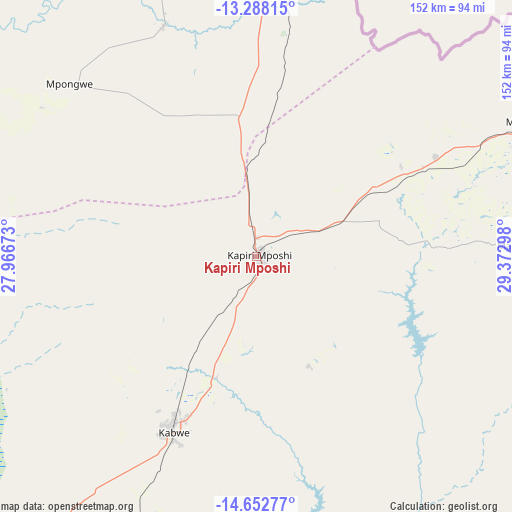
Kapiri Mposhi GPS coordinates[2]
13° 58' 17.292" South, 28° 40' 11.46" East
| Map corner | latitude | longitude |
|---|---|---|
| Upper-left | -13.28815°, | 27.96673° |
| Center: | -13.97147°, | 28.66985° |
| Lower-right: | -14.65277°, | 29.37298° |
| Map W x H: | 151.7×151.7 km | = 94.3×94.3mi |
| max Lat: | -8.46887° ⇑59.1% North |
| Kapiri Mposhi: | -13.97147° |
| min Lat: | ⇓40.9% South -17.84194° |
| min Long | Kapiri Mposhi | max Long |
| 22.67926° | 28.66985° | 33.1782° |
| W 57.6%⇐ | ⇒42.4% E |
Elevation
Elevation of Kapiri Mposhi is 1265 m = 4150 ft, and this is 121.6 m = 399 ft above average elevation for this country.
| Max E: |
1622 m = 5322 ft | 33.3% |
| Kapiri Mposhi | 1265 m 4150 ft | |
| Avg. | 1143.4 m = 3751 ft | |
Min E: |
328 m = 1076 ft | 66.7% |
See also: Zambia elevation on elevation.city.
Geographical zone
Kapiri Mposhi is located in South Torrid zone (between Equator and Tropic of Capricorn). Distance of this Southern Tropic circle is 1052.4 km =653.9 mi to South.| Distance of | km | miles | from Kapiri Mposhi |
|---|---|---|---|
| Equator | 1553.5 | 965.3 | to North |
| Tropic Capricorn | 1052.4 | 653.9 | to South |
| Antarctic Circle | 5847.7 | 3633.6 | to South |
| South Pole | 8453.6 | 5252.8 | to South |


Nearby cities:
15 places around Kapiri Mposhi: (largest is in red/bold)
• Chambishi
163.1 km =101.3 mi,  335°
335°
• Chibombo
99.9 km =62.1 mi,  220°
220°
• Chililabombwe
200.8 km =124.8 mi,  332°
332°
• Chingola
181.6 km =112.8 mi, 332°
• Chongwe
151 km =93.8 mi,  179°
179°
• Kabwe
58.1 km =36.1 mi,  204°
204°
• Kalulushi
140.2 km =87.1 mi, 333°
• Kitwe
139.1 km =86.4 mi, 339°
• Luanshya
96.8 km =60.1 mi, 343°
• Lusaka
164.8 km =102.4 mi,  194°
194°
• Mkushi
87.4 km =54.3 mi,  63°
63°
• Mpongwe
75.7 km =47 mi,  312°
312°
• Mufulira
164.8 km =102.4 mi, 343°
• Ndola
112.7 km =70 mi,  358°
358°
• Serenje
188.1 km =116.9 mi, 64°
Sources, notices
• [Note1] Compared only with cities in Zambia existing in our database
• [Src1] Map data: © OpenStreetMap contributors (CC-BY-SA)
• [Src2] Other city data from geonames.org with taken over terms of usage.
• [Src3] Geographical zone / Annual Mean Temperature by Robert A. Rohde @ Wikipedia
