Lusaka geodata
Lusaka is a capital of a political entity; located in Zambia in Africa/Lusaka (GMT+2) time zone. With population of 1,267,440 people, there are 0 cities with bigger population in this country. Compared to other cities in Zambia, 78.8% of cities are located further ↑North; 51.5% of cities are located further ←West and 68.2% of cities have lower elevation than Lusaka. Note1


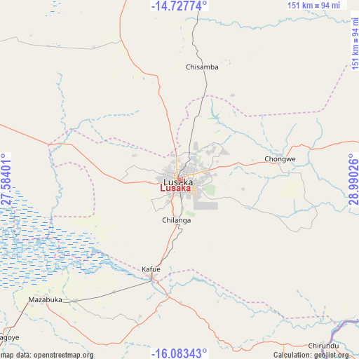
Lusaka GPS coordinates[2]
15° 24' 24.084" South, 28° 17' 13.668" East
| Map corner | latitude | longitude |
|---|---|---|
| Upper-left | -14.72774°, | 27.58401° |
| Center: | -15.40669°, | 28.28713° |
| Lower-right: | -16.08343°, | 28.99026° |
| Map W x H: | 150.7×150.7 km | = 93.6×93.6mi |
| max Lat: | -8.46887° ⇑78.8% North |
| Lusaka: | -15.40669° |
| min Lat: | ⇓21.2% South -17.84194° |
| min Long | Lusaka | max Long |
| 22.67926° | 28.28713° | 33.1782° |
| W 51.5%⇐ | ⇒48.5% E |
Elevation
Elevation of Lusaka is 1277 m = 4190 ft, and this is 133.6 m = 438 ft above average elevation for this country.
| Max E: |
1622 m = 5322 ft | 31.8% |
| Lusaka | 1277 m 4190 ft | |
| Avg. | 1143.4 m = 3751 ft | |
Min E: |
328 m = 1076 ft | 68.2% |
See also: Lusaka elevation on elevation.city.
Geographical zone
Lusaka is located in South Torrid zone (between Equator and Tropic of Capricorn). Distance of this Southern Tropic circle is 892.9 km =554.8 mi to South.| Distance of | km | miles | from Lusaka |
|---|---|---|---|
| Equator | 1713.1 | 1064.5 | to North |
| Tropic Capricorn | 892.9 | 554.8 | to South |
| Antarctic Circle | 5688.1 | 3534.4 | to South |
| South Pole | 8294 | 5153.7 | to South |


Nearby cities:
15 places around Lusaka: (largest is in red/bold)
• Chibombo
86.6 km =53.8 mi,  344°
344°
• Choma
208.8 km =129.7 mi,  221°
221°
• Chongwe
43.2 km =26.8 mi,  78°
78°
• Gwembe
141.4 km =87.9 mi,  210°
210°
• Kabwe
108.1 km =67.2 mi,  9°
9°
• Kafue
41.9 km =26 mi,  195°
195°
• Kapiri Mposhi
164.8 km =102.4 mi, 14°
• Mazabuka
76.3 km =47.4 mi,  229°
229°
• Monze
130 km =80.8 mi, 221°
• Mpongwe
211.5 km =131.4 mi,  356°
356°
• Mumbwa
139.7 km =86.8 mi,  289°
289°
• Nakambala
72 km =44.7 mi, 228°
• Namwala
201.7 km =125.3 mi,  259°
259°
• Siavonga
133.6 km =83 mi,  160°
160°
• Sinazongwe
224.2 km =139.3 mi, 203°
Sources, notices
• [Note1] Compared only with cities in Zambia existing in our database
• [Src1] Map data: © OpenStreetMap contributors (CC-BY-SA)
• [Src2] Other city data from geonames.org with taken over terms of usage.
• [Src3] Geographical zone / Annual Mean Temperature by Robert A. Rohde @ Wikipedia
