Luanshya geodata
Luanshya (Copperbelt) is a populated place; located in Zambia in Africa/Lusaka (GMT+2) time zone. With population of 113,365 people, there are 6 cities with bigger population in this country. Compared to other cities in Zambia, 56.1% of cities are located further ↓South; 53% of cities are located further ←West and 62.1% of cities have lower elevation than Luanshya. Note1


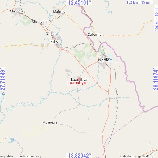
Luanshya GPS coordinates[2]
13° 8' 12.012" South, 28° 24' 59.796" East
| Map corner | latitude | longitude |
|---|---|---|
| Upper-left | -12.45101°, | 27.71349° |
| Center: | -13.13667°, | 28.41661° |
| Lower-right: | -13.82042°, | 29.11974° |
| Map W x H: | 152.3×152.3 km | = 94.6×94.6mi |
| max Lat: | -8.46887° ⇑43.9% North |
| Luanshya: | -13.13667° |
| min Lat: | ⇓56.1% South -17.84194° |
| min Long | Luanshya | max Long |
| 22.67926° | 28.41661° | 33.1782° |
| W 53%⇐ | ⇒47% E |
Elevation
Elevation of Luanshya is 1238 m = 4062 ft, and this is 94.6 m = 310 ft above average elevation for this country.
| Max E: |
1622 m = 5322 ft | 37.9% |
| Luanshya | 1238 m 4062 ft | |
| Avg. | 1143.4 m = 3751 ft | |
Min E: |
328 m = 1076 ft | 62.1% |
See also: Luanshya elevation on elevation.city.
Geographical zone
Luanshya is located in South Torrid zone (between Equator and Tropic of Capricorn). Distance of this Southern Tropic circle is 1145.3 km =711.7 mi to South.| Distance of | km | miles | from Luanshya |
|---|---|---|---|
| Equator | 1460.7 | 907.6 | to North |
| Tropic Capricorn | 1145.3 | 711.7 | to South |
| Antarctic Circle | 5940.5 | 3691.3 | to South |
| South Pole | 8546.4 | 5310.5 | to South |


Nearby cities:
15 places around Luanshya: (largest is in red/bold)
• Chambishi
68.5 km =42.6 mi,  324°
324°
• Chibombo
173.1 km =107.6 mi,  192°
192°
• Chililabombwe
107.3 km =66.7 mi, 323°
• Chingola
88.9 km =55.2 mi, 319°
• Kabwe
145.7 km =90.5 mi,  178°
178°
• Kalulushi
47.9 km =29.8 mi,  313°
313°
• Kapiri Mposhi
96.8 km =60.1 mi,  163°
163°
• Kataba
203.5 km =126.4 mi,  46°
46°
• Kitwe
43.2 km =26.8 mi,  329°
329°
• Mansa
221.5 km =137.6 mi,  13°
13°
• Mkushi
118.6 km =73.7 mi,  116°
116°
• Mpongwe
50.2 km =31.2 mi,  214°
214°
• Mufulira
68 km =42.3 mi,  343°
343°
• Ndola
31 km =19.3 mi, 50°
• Serenje
197.2 km =122.5 mi,  93°
93°
Sources, notices
• [Note1] Compared only with cities in Zambia existing in our database
• [Src1] Map data: © OpenStreetMap contributors (CC-BY-SA)
• [Src2] Other city data from geonames.org with taken over terms of usage.
• [Src3] Geographical zone / Annual Mean Temperature by Robert A. Rohde @ Wikipedia
