Nakambala geodata
Nakambala (Southern) is a populated place; located in Zambia in Africa/Lusaka (GMT+2) time zone. With population of 10,425 people, there are 40 cities with bigger population in this country. Compared to other cities in Zambia, 84.8% of cities are located further ↑North; 63.6% of cities are located further →East and 74.2% of cities have higher elevation than Nakambala. Note1


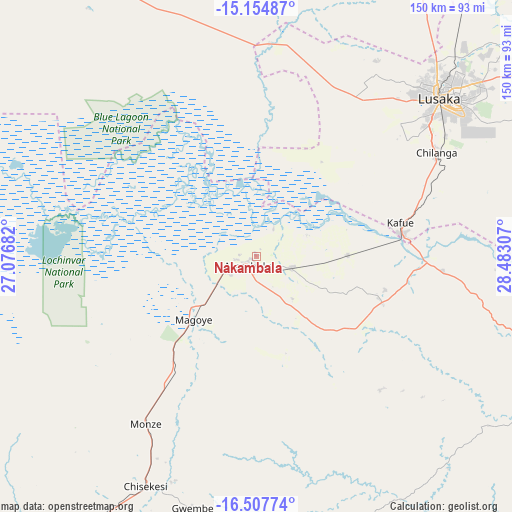
Nakambala GPS coordinates[2]
15° 49' 56.784" South, 27° 46' 47.784" East
| Map corner | latitude | longitude |
|---|---|---|
| Upper-left | -15.15487°, | 27.07682° |
| Center: | -15.83244°, | 27.77994° |
| Lower-right: | -16.50774°, | 28.48307° |
| Map W x H: | 150.4×150.4 km | = 93.5×93.5mi |
| max Lat: | -8.46887° ⇑84.8% North |
| Nakambala: | -15.83244° |
| min Lat: | ⇓15.2% South -17.84194° |
| min Long | Nakambala | max Long |
| 22.67926° | 27.77994° | 33.1782° |
| W 36.4%⇐ | ⇒63.6% E |
Elevation
Elevation of Nakambala is 1023 m = 3356 ft, and this is 120.4 m = 395 ft below average elevation for this country.
| Max E: |
1622 m = 5322 ft | 74.2% |
| Avg. | 1143.4 m = 3751 ft | |
| Nakambala | 1023 m = 3356 ft | |
Min E: |
328 m = 1076 ft | 25.8% |
See also: Zambia elevation on elevation.city.
Geographical zone
Nakambala is located in South Torrid zone (between Equator and Tropic of Capricorn). Distance of this Southern Tropic circle is 845.5 km =525.4 mi to South.| Distance of | km | miles | from Nakambala |
|---|---|---|---|
| Equator | 1760.4 | 1093.9 | to North |
| Tropic Capricorn | 845.5 | 525.4 | to South |
| Antarctic Circle | 5640.8 | 3505 | to South |
| South Pole | 8246.7 | 5124.3 | to South |


Nearby cities:
15 places around Nakambala: (largest is in red/bold)
• Chibombo
134.4 km =83.5 mi,  13°
13°
• Choma
137.6 km =85.5 mi,  217°
217°
• Chongwe
111.7 km =69.4 mi,  59°
59°
• Gwembe
76.2 km =47.3 mi,  194°
194°
• Kabwe
169.9 km =105.6 mi,  24°
24°
• Kafue
43.5 km =27 mi,  80°
80°
• Kapiri Mposhi
227.9 km =141.6 mi, 24°
• Lusaka
72 km =44.7 mi,  48°
48°
• Maamba
183.3 km =113.9 mi,  201°
201°
• Mazabuka
4.3 km =2.7 mi,  232°
232°
• Monze
59.3 km =36.8 mi,  212°
212°
• Mumbwa
121.8 km =75.7 mi,  320°
320°
• Namwala
143.8 km =89.4 mi,  273°
273°
• Siavonga
126.5 km =78.6 mi,  128°
128°
• Sinazongwe
162.5 km =101 mi, 192°
Sources, notices
• [Note1] Compared only with cities in Zambia existing in our database
• [Src1] Map data: © OpenStreetMap contributors (CC-BY-SA)
• [Src2] Other city data from geonames.org with taken over terms of usage.
• [Src3] Geographical zone / Annual Mean Temperature by Robert A. Rohde @ Wikipedia
