Kafue geodata
Kafue (Lusaka) is a populated place; located in Zambia in Africa/Lusaka (GMT+2) time zone. With population of 47,554 people, there are 14 cities with bigger population in this country. Compared to other cities in Zambia, 83.3% of cities are located further ↑North; 53% of cities are located further →East and 81.8% of cities have higher elevation than Kafue. Note1


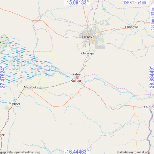
Kafue GPS coordinates[2]
15° 46' 8.796" South, 28° 10' 52.896" East
| Map corner | latitude | longitude |
|---|---|---|
| Upper-left | -15.09133°, | 27.47824° |
| Center: | -15.76911°, | 28.18136° |
| Lower-right: | -16.44463°, | 28.88449° |
| Map W x H: | 150.5×150.5 km | = 93.5×93.5mi |
| max Lat: | -8.46887° ⇑83.3% North |
| Kafue: | -15.76911° |
| min Lat: | ⇓16.7% South -17.84194° |
| min Long | Kafue | max Long |
| 22.67926° | 28.18136° | 33.1782° |
| W 47%⇐ | ⇒53% E |
Elevation
Elevation of Kafue is 996 m = 3268 ft, and this is 147.4 m = 484 ft below average elevation for this country.
| Max E: |
1622 m = 5322 ft | 81.8% |
| Avg. | 1143.4 m = 3751 ft | |
| Kafue | 996 m = 3268 ft | |
Min E: |
328 m = 1076 ft | 18.2% |
See also: Kafue elevation on elevation.city.
Geographical zone
Kafue is located in South Torrid zone (between Equator and Tropic of Capricorn). Distance of this Southern Tropic circle is 852.6 km =529.8 mi to South.| Distance of | km | miles | from Kafue |
|---|---|---|---|
| Equator | 1753.4 | 1089.5 | to North |
| Tropic Capricorn | 852.6 | 529.8 | to South |
| Antarctic Circle | 5647.8 | 3509.4 | to South |
| South Pole | 8253.7 | 5128.6 | to South |


Nearby cities:
15 places around Kafue: (largest is in red/bold)
• Chibombo
124.2 km =77.2 mi,  354°
354°
• Choma
172 km =106.9 mi,  227°
227°
• Chongwe
72.6 km =45.1 mi,  47°
47°
• Gwembe
101.6 km =63.1 mi,  217°
217°
• Kabwe
149.7 km =93 mi,  10°
10°
• Kapiri Mposhi
206.7 km =128.4 mi, 14°
• Lusaka
41.9 km =26 mi,  15°
15°
• Maamba
208.9 km =129.8 mi,  211°
211°
• Mazabuka
47.4 km =29.5 mi,  258°
258°
• Monze
94 km =58.4 mi, 232°
• Mumbwa
148.5 km =92.3 mi,  306°
306°
• Nakambala
43.5 km =27 mi, 260°
• Namwala
186.5 km =115.9 mi,  270°
270°
• Siavonga
102.4 km =63.6 mi,  146°
146°
• Sinazongwe
182.8 km =113.6 mi,  204°
204°
Sources, notices
• [Note1] Compared only with cities in Zambia existing in our database
• [Src1] Map data: © OpenStreetMap contributors (CC-BY-SA)
• [Src2] Other city data from geonames.org with taken over terms of usage.
• [Src3] Geographical zone / Annual Mean Temperature by Robert A. Rohde @ Wikipedia
