Kansanshi geodata
Kansanshi (North-Western) is a populated place; located in Zambia in Africa/Lusaka (GMT+2) time zone. With population of 40,705 people, there are 17 cities with bigger population in this country. Compared to other cities in Zambia, 71.2% of cities are located further ↓South; 77.3% of cities are located further →East and 95.5% of cities have lower elevation than Kansanshi. Note1


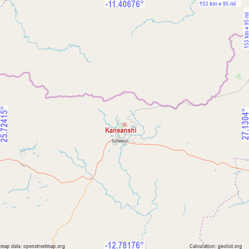
Kansanshi GPS coordinates[2]
12° 5' 42.504" South, 26° 25' 38.172" East
| Map corner | latitude | longitude |
|---|---|---|
| Upper-left | -11.40676°, | 25.72415° |
| Center: | -12.09514°, | 26.42727° |
| Lower-right: | -12.78176°, | 27.1304° |
| Map W x H: | 152.9×152.9 km | = 95×95mi |
| max Lat: | -8.46887° ⇑28.8% North |
| Kansanshi: | -12.09514° |
| min Lat: | ⇓71.2% South -17.84194° |
| min Long | Kansanshi | max Long |
| 22.67926° | 26.42727° | 33.1782° |
| W 22.7%⇐ | ⇒77.3% E |
Elevation
Elevation of Kansanshi is 1429 m = 4688 ft, and this is 285.6 m = 937 ft above average elevation for this country.
| Max E: |
1622 m = 5322 ft | 4.5% |
| Kansanshi | 1429 m 4688 ft | |
| Avg. | 1143.4 m = 3751 ft | |
Min E: |
328 m = 1076 ft | 95.5% |
See also: Kansanshi elevation on elevation.city.
Geographical zone
Kansanshi is located in South Torrid zone (between Equator and Tropic of Capricorn). Distance of this Southern Tropic circle is 1261.1 km =783.6 mi to South.| Distance of | km | miles | from Kansanshi |
|---|---|---|---|
| Equator | 1344.9 | 835.7 | to North |
| Tropic Capricorn | 1261.1 | 783.6 | to South |
| Antarctic Circle | 6056.3 | 3763.2 | to South |
| South Pole | 8662.2 | 5382.4 | to South |


Nearby cities:
15 places around Kansanshi: (largest is in red/bold)
• Chambishi
186.5 km =115.9 mi,  108°
108°
• Chililabombwe
154.6 km =96.1 mi,  101°
101°
• Chingola
165.4 km =102.8 mi, 106°
• Kalengwa
217 km =134.8 mi,  225°
225°
• Kalulushi
199.2 km =123.8 mi, 114°
• Kasempa
164.7 km =102.3 mi,  203°
203°
• Kitwe
209.3 km =130.1 mi, 112°
• Luanshya
245 km =152.2 mi,  118°
118°
• Mansa
286.5 km =178 mi,  69°
69°
• Mpongwe
244.6 km =152 mi,  130°
130°
• Mufulira
203.4 km =126.4 mi, 104°
• Mufumbwe
249.6 km =155.1 mi,  224°
224°
• Mwinilunga
221 km =137.3 mi,  280°
280°
• Ndola
258.3 km =160.5 mi, 111°
• Solwezi
9.2 km =5.7 mi,  206°
206°
Sources, notices
• [Note1] Compared only with cities in Zambia existing in our database
• [Src1] Map data: © OpenStreetMap contributors (CC-BY-SA)
• [Src2] Other city data from geonames.org with taken over terms of usage.
• [Src3] Geographical zone / Annual Mean Temperature by Robert A. Rohde @ Wikipedia
